Firstly,
I just want to acknowledge Chris Dixon – Wild & Co for everything he did to
enable Geoquest AR to still go ahead this year, after the announcement that it
had been postponed and then that a ‘Wildside’ event would take its place. The
fact that Chris and Richard Old worked together to put an event together pretty
quickly, provides some hope that ‘Geoquest - Australia’s Premier Adventure
Race’ will continue in years to come. I was proud to be representing Mountain
Designs which itself is also going
through a change and am ever hopeful that Mountain Designs may be in a position
to continue their sponsorship of this event in the future. For this reason was
so good that many of Australia’s best and most experienced adventure racers
also supported the event, as the feedback provided on the race to the race
directors, should be well balanced.
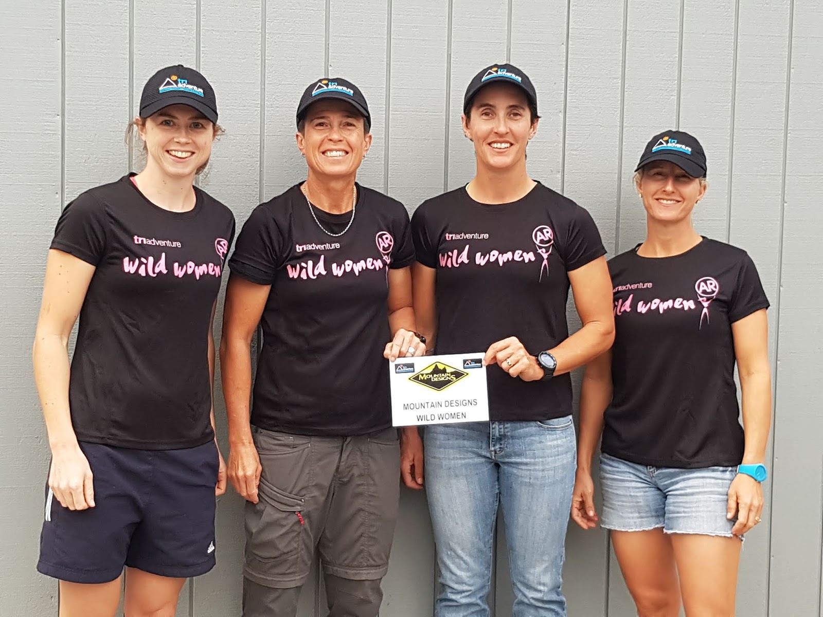
Our
Mountain Designs Wild Women was a little different to XPD and Rogue. No Alina,
No Ali, No Gina and No Liz, meant we had some pretty big shoes to fill, however
Cass Kimlin and I were super confident that Kelly-Anne Speight and Amie Munson
would step up to the challenge and they did! Kelly-Anne first joined us at an
AR clinic about 2 years ago and has gone from strength to strength ever since,
competing mainly in Cross Tri, Xterra and Trail running events. She raced the
Geo Half with Jan as a Cowgirl last year and her potential was recognised. Amie
has a background in Ironman Triathlon, however Cass has been slowly pushing her
to the AR side of the fence. Like Kelly-Anne, Amie joined up with Tri Adventure
and has been able to come on some of our weekend adventures and instantly we
could see that she would be tough enough to do an event such as Geoquest.
 |
New look MD Wild Women - Kelly-Anne, Kim, Cass, Amie
|
Anyway,
from the live tracking, Facebook and results, you will see that our team
finished the event in overall 10th place, just over 46hrs (not much
under the 48). This was a little longer than we anticipated, however given the
reality that some teams did not finish due to course difficulty or injured team
members and that some teams missed checkpoints, we were extremely satisfied to
finish as a team of 4 knowing that we had found every CP on the course that we
were required to get. So now I will try
to compare this edition to previous editions of Geoquest in the hope that many
of you out there will, in the future, continue to support the event, or be inspired
to be a part of it, as I have been for the past 14 years.
Pre Event – Planning & Preparation
Course
logistics planner was revealed two weeks prior to the event, which was great
considering that registration was at 4pm and we would not get the maps till
after the event briefing at 7pm. We managed to get rego out of the way early
and went back to our place to sort gear, then headed early to the briefing at
the Serenity Resort had a great night out eating pizza and wine, catching up
with many AR friends. I thought we would be up till midnight doing maps,
however as we only received the maps for the first 5 legs of the course, we did
not have to spend all night marking them up, but did cut extra contact, pens
and highlighters and put them in boxes for out on course. It was going to be an
early start as we needed to drop off boxes at 5am and race start was at 6pm. It
would have been after 10.30 by the time I lay down, but could not sleep……yes my
mind was active and by 1pm I had still not slept….I was hoping this lack of
sleep would not affect me in the race.
 |
| One of Kim's logistics planners...this only lists some of the gear we put in those boxes! |
 |
| As we had no support crew we had to make sure we got the packing right! |
Race Day – Event Start
We
were up at 4.15 am and I enjoyed my fruit toast and coffee (standard pre- event
breakfast) and we were out the door by 4.55. We rode to HQ on our bikes, while
Jan & Angela (Kelly-Anne’s sister) drove our gear there, we were one of the
first team to arrive, so we sat on the resort bar couches before grabbing our tracker
and heading to the start. While walking to the start Angela was taken out by a
kangaroo…..yes…..not joking! She was ok, but somewhat surprised! It was still
dark and we needed our #Ay Ups to see the maps, even though the sun was trying
hard to light up the sky but dimmed by the clouds.
 |
| It was still dark when we started - Kim and Kelly-Anne had their Ay Up's on....and bright pink gaiters! |
 |
| Serenity Diamond Beach - the place where we started and finished Wildside Geoquest - Special Edition. |
Leg 1 Trek 21k Diamond Beach to Forster
This
was a relatively simple leg, run down the beach to Forster, similar to the
finish of a previous Geoquest. Typically Geoquest starts on a beach somewhere,
however usually with an ocean paddle…. this was missing from this edition! The
first CP was a little tricky to find as it was much further around the headland
than most anticipated.... the end of a track was off the track that we were
running on, so easily missed by teams at the front who were ‘running to the end
of the track’ maybe? CP2 in the cave was a fun little rock scramble, and as the
tide was on its way out…no swimming required!
 |
| CP 2 in the little cave |
We then had to continue to run
down 9-mile beach about 8km to CP3 on the edge of the Tuncurry Golf Course,
lucky for us, we could see teams ahead and footprints, as there were not too
many features to guarantee the spot was right, despite us trying to use time to
gauge distance and locate minor tracks along the way. We finished the leg with
a short path run similar to the end of the old Forster Ironman / Forster
Anaconda over the Forster Tuncurry Bridge to the boat harbour. This TA was
marked on main beach however at the briefing we were told that for safety
reasons the paddle would start in the river rather than on the beach! So,
absolutely no ocean paddle in this event….given we only had the CTR’s to paddle
maybe this was not a bad call, as they are not great in the surf!
 |
Girls running on the beach towards Forster
  |
Leg 2 – Kayak 25k – Forster to Wang Wauk
We
only had one CP to locate on this leg, yet we had to navigate past oyster
leases and locate the Coolongolook River and then the Wang Wauk River to get to TA 2. Cass and Amie
paddled together and I teamed up with Kelly-Anne. Knowing that Cass and Amie would be stronger,
KA and I sat on their wash for a while, just trying to save energy. After
around 9km we were starting to get cold, so just as we entered the Coolongolook
River, we stopped to put on thermals, after paddling to CP 5 I was still cold
so had to take off my gloves (as they were wet) and instantly I warmed up! A
mirage paddled past and we were in awe of having a faster craft….like we would
have had in previous Geoquest events! We arrived at TA2 around 12.30pm around
3hrs ahead of our schedule.
 |
| Despite the lack of sun, it was a perfect day for Kayaking on the Wang Wauk River! |
Leg 3-5 MTB 47k, 20km, 5km Wang Wauk to Tinonee, via Wallamba, Kiwarrak State Forest.
Despite
the dog poo all over the grass at this TA, the officials were lovely, one of
them being Jaci, whom I had met after Wildside, when staying at Tom &
Alina’s place in Canberra. We chatted about our Coast to Coast experiences
before our team checked out of the TA heading for the Kiwarrak MTB Park. This
leg was fairly straight forward until after CP 9 where the trail on the map
looked like a fire trail was an indistinct track beside a fence……here we were
caught by the X-trail Rejects so together we had fun climbing and hike a biking
up to the Southern Boundary Trail. Unfortunately for them, Sarah crashed on a
water bar, right in front of Amie, Cass who stopped with Dave and Brad…..before
they said for us to keep going….it was the end of the race for Sarah however
the boys continued on the course later. We arrived at the MTB park just after
it was dark and were provided with a map of the trail and told we were required
to find 5 of the 7 CP’s. We chose C A G F B in that order. All was good finding
C and A, however choosing to follow the MTB trail rather than fire trail to G
messed us up, as the T trail at the end seemed like a Fire trail and not MTB
trail as indicated. Looking now at the tracker it seems so simple, but we ended
up going back to CP A on the MTB trail (this was fun with 3 bridges and we got
to ride it both ways). I had a, not so elegant, crash in front whilst spending
too much time looking at the map rather than the pot holes on the trail….air
shot out of my tyre and my map board cracked again (lucky for gaffer tape). The
crash looked worse than it was and soon we were back rolling….thanks Susie and
Ange for checking I was okay…. so great to see your team out there so many
times!
 |
| Have a look at our tracker and see where you think the awesome singletrack was......the one we rode both ways! |
Anyway, we soon found G and then rode the fire trails to F on the black
track and B under the bridge. It then did not take long get back to the TA,
where we received the rest of our maps and headed to TA 3 around 9pm….. Somehow,
we were 2hrs ahead of our schedule. This had been a typical Geoquest bike leg,
however I was anticipating a ‘course split’ at the MTB park, as in more recent
years Geocentric had been throwing something like that in to split up the teams
and challenge the navigators!
Leg 6 – Kayak – 25kTinonee to Brimbin
As I
mentioned earlier we only had maps for the first 5 legs, so at the previous TA
we were given our package with the rest of the maps, so we decided to mark some
up when we arrived at this Kayak TA. We got changed into our kayaking gear
first and then Cass and I started on the maps, while Amie and KA wandered over
to the cake stall 😊 and ordered some hot coffee and jam &
scones. So even though we did not have support crews, the scout groups who were
manning the TA’s had some food on offer which was great, and quite different to
what we are used to in an unsupported event. We decided to mark up the paddle
–and the trek (Leg 6 & 7) and leave the MTB till later. I think we got into
this TA around 9.30pm, however did not leave till closer to 10.30, as just as
we were about to leave there was a glitch with the pedal of one of the kayaks
we were given. Soon we were off and paddling…I teamed up with Amie and Cass with
KA. It was very dark out there yet we found it sometimes easier to navigate
with our AY UP lights off! Unfortunately
CP 17 was an out and back on the Manning River, however we did have fun
climbing up the goat track to the lookout…Cass spotted the rope swing and then
the track! We worked out we were paddling around 6km/h roughly as we paddled
back past the TA, and we had a bout 5km to CP18 which was on Coocumbac Island Nature Reserve. The CP was
marked on a track junction and looked like it was almost in the middle of the
island. We paddled close to the right edge of it and we came across some
stairs, wow great place to get out we thought, and then bang there was the
CP….lucky we did not try to bush bash in earlier!

CP 19 was easy as we passed
by the town of Taree then we had to look for the Dawson River on our left! We
saw the inlet and up the Dawson we went all the way to CP22 and then all the
way to the TA. It was actually quite a beautiful paddle as the sky was full of
stars and there was not a breath of wind on the water…it was just quite
long…..so we sang a few songs along the way including some of Amie’s favourite
country hits! We had our light off most of the time, and Amie became really
good at sensing when I was about to run into a tree or low branch……and I
perfected my quick back paddling technique! Unfortunately, the end the paddle
was a bit muddy and there was a bit of a hike up to the TA, however we did not
have to carry the kayaks up (yay!), as we were going to paddle back for the
same spot after our Trek & MTB. It was now around 4am.
Leg 7 Trek – 16k - Brimbin Nature Reserve to Lansdown
At
this TA were treated to a fire and they had hot noodle soup for sale, so we
hooked into that as we were getting dry and warm. I could not believe how dry I
stayed during the night paddle with my cag long pants and my Mountain Designs
Pro-Elite Gore-Tex jacket….all I had to change was my socks! I was prepared for
a typical Geoquest Trek leg where we would spend hours off track, trekking up
and down creek lines or climbing steep mountains and rolling down into rugged
rainforests to find CP’s. This was not the case, this trek was pretty much all
on track and flat, so the biggest challenge was that there were a few trails
marked that we obviously overgrown or non-existent, and we had to hike maybe
150m into a creek junction….that was it! Cass took the lead navigator role on
this leg and we sailed through the course - CP 24, 25, 26 and 27, seeing Susie
and Ange again along the way. The sun was now shining and it was a beautiful
day out in Yarrat State Forest. We arrived into TA6 at around 9.30am ahead of
one team that had left the previous TA before us......now that’s always a
positive!

Leg 8 MTB – 66kms – Lansdown – Brimbin Nature Reserve via Coorabakh National Park
The
officials at the TA informed us that this leg would be EPIC….and that we should
pack our trekking shoes as there may not be much riding. He then told us he was
out of water!!! We were about to embark on a leg that would take us 7-8 hrs
according to the course notes and we had no water….whaaaat!!! We were told that
water ran out after some of the first teams came through and it had not been
refilled. Luckily a supported team’s crew went to a nearby farm and asked to
fill the water container, otherwise we, and other teams behind, would have been
in some trouble!! We got all our gear sorted for the leg, then Cass and I sat
down to look at the maps for Leg 8 and 9. I think because we were a bit tired,
it was like a trying to piece together a puzzle as we had to somehow get the
map to join CP 29,30,31,32, 33,34 together! We had our highlighters out and
soon it made some sense…..we made a plan and off we went!

It was a flat ride
past CP 29 but then a typical Geoquest climb up to CP30. Here we were looking
for a high point to the left of the track. When we arrived we could hear
another team further up calling out, we went in early, but no CP, we walked the
ridge for a bit, but no CP. Soon there were about 3 teams all looking for the
same CP, we decided to go south as the track ahead seemed to bend, like we had
gone too far. We ditched the bikes and hiked on the ridge, another team was
heading our way and saw us, then did a U-turn just as we sighted the CP, how
lucky were they, as we had been there for some 15mins. The other teams then
found the CP and they all promptly sped past us as we rode the trails somewhat
cautiously! We had some big climbing
ahead of us, Amie and KA were on fire, yet poor Cass was having a battle with
the Sleep monsters! We tried everything to wake her up, however not even my
afternoon talk back radio request show could not entertain her enough! Luckily
we came across some people on the course…..we stopped had a chat and Cass was
awake – Yay! We had an awesome descent into CP31 and it seemed at this point
like we were on the set of Jurassic park….. I was expecting to see a big dinosaur
rear its head through the massive grey gums ….. we enjoyed our little hike into
the CP and then a short climb up to Big Nellie. This CP was hanging at the shelter
with a note, saying we did not have to do the climb due to the conditions.

There was also a note to take care riding into and out of CP 33….so we did. It
was now raining and the roads were very slippery…Slaters Road ended and turned
into a very sketchy single track, we rode cautiously and soon arrived at the
gate – CP 33. Unfortunately for us, we did not choose a direct route from CP
33. I did not pick up that the road from CP33 went back through TA6, so we did
a 12k detour back around past CP29……oh well it was a nice flat fast road, and
probably only took 40minutes……but something we could have done without! Lucky
for us we had absolutely no idea we had done this so we enjoyed the mudslide
ride into to TA 6 at around 6.30pm. It
was great to see a few familiar faces at the TA, Glenn Smith was there loading
bikes, and Darryn & Pete (Tri Adventure Cowboys) were there to say hi! Unfortunately they had to withdraw due to a
minor bike issue – Mark’s bike flew off the car before they set off on their
second bike…..maybe they were quietly relieved! The other girls team was also
there at the TA, as they had short-coursed themselves option to miss several
mandatory CP’s on the bike….saving them maybe 6-8hrs!

Leg 9 Kayak - 27km - Brimbin Nature Reserve to Cabbage Tree Island
We
had resigned to the fact that we would not finish by midnight, so opted to cook
up a feast before we headed out on the final kayak. Honestly, we did not waste
any time, boiling water and preparing a Back Country meal and hot coffee while
we were getting our gear sorted. It did seem to take us a while as we had to
take pedals on and off the bikes at the start and or each bike leg, take map
boards on and off and just generally stuff around getting gear. Normally in
Geoquest we would have our support crew to do this and teams can be in and out
of TA’s in a flash! Anyway……this was not the case….so I had a good look at the
maps with Cass, while I finished my meal, as Amie and KA did the final pack up
of the gear. Down to the river we went and off we set on our longest paddle of
the race! I was with KA this time,
steering from the front, and Cass with Amie at the front....we enjoyed the fact
that we could mix the paddling pairs up a bit and choose kayaks that steered
from the front or back! We paddled back down the Dawson River past CP22 and
then into the Manning River again, however this time heading further south east
into the South Manning River. We had a few other teams around us, and we were
singing out loud…..it was pretty hard to stay awake on this second night
without sleep, but we managed well…..coffee beans…..coke…..lots of singing….
and yelling out to the beautiful night sky! It would have been so easy to just
lie down in the kayak and drift to sleep……as it was now after midnight…..but we
had a race to finish….so on, we paddled! The final section of the paddle was
mapped as a maze of oyster leases, however these were not evident, so we
navigated our way around Cabbage Tree Island into the final TA 7.
 |
| This is not the kayak we paddled.....but were were certainly used to night paddling after this special edition of Geoquest! |
Leg 10 – Coastal Trek 11kms Mudbishops Point Reserve to Diamond Beach
We
had no box at this TA, so there was not too much to do, other than get going
and run to the finish! Again, surprisingly I was dry after the paddle thanks to
my waterproof Mountain Designs Gore-Tex jacket and pants, so all I had to do
was remove an itchy thermal top that I had mistakenly packed (silly me). I felt
like I had itchy grubs in my shirt for the paddle….maybe that’s why I found it
easier to stay awake! Anyway, we got out
of there pretty quickly and headed for the beach! We enjoyed a little bush bash
from the road to the beach to avoid and OOB area then ran (well it probably
looked like a hobble) down the along the beach covered in seaweed and rocks
towards CP 38. We had been told we did not have to find it, but we accidently
ended up out at the lookout anyway as we were trying to avoid the OOB area! It
was a lovely track, but not quite the right direction. Soon we were back on the
beach heading for HQ! The tide was high, so it was a soft sand run most of the
way….Kelly Anne was on fire, and I was just keeping up running in her
footsteps. We arrived back at Serenity Diamond Beach Resort at around 4.30am
after 46 hrs or so of racing without any sleep or major stops! I thought…..Wow
well done my Mountain Designs Wild Women Team mates, you are all amazing! We
were greeted on the finish line by our Tri Adventure friends and family as well
as Race Director Chris Dixon.
The wrap up!
So,
we managed to get an hour or so sleep before the post event BBQ. This is one of
my favourite parts of the Geoquest, as it is when you share all your stories
with all of the other teams and celebrate your fortunes and of course
contemplate the what ifs! Due to the lack of support crews for this event the
BBQ unfortunately seemed a bit light on in atmosphere…..anyway I am sure that
may change in the future when the event grows and our new race director Chris
Dixon add his own flavour to the event.

Mountain Designs Wild Women hope to be back in some way shape or form at GEOQUEST 2019,
so we and Tri Adventure, would love to see more of you out there too. Please
don’t hesitate to contact us if you want to put a team together for this event
next year or other events on the AR calendar as we are super keen to increase
participation in the sport through development of skills and fitness is a fun,
safe and supportive environment!
No comments:
Post a Comment